Although Stages 5 and 6 of the Lantau Trail is shorter in length than Stages 7 and 8 which, when done in reverse, takes one from Shek Pik Reservoir around to Fan Lau and then eventually to Tai O, it's actually more demanding -- seeing as it goes up and down a few hills, including one that's 490 meters high and another whose peak is 465 meters above sea level.
But even when done on a less clear air day than my hiking friend and I would have liked, we still really enjoyed the 11 kilometer length excursion -- and, at the end of it, agreed that it's a hike we'd like to repeat at some point in time, albeit on a clearer air as well as cool day, because it's really quite enjoyable even if also on the challenging side! :)
Right from the start of the hike, we were made
well aware that this would be a arduous one,
with many hills waiting to be scaled up!
Fortunately the trail really is well constructed
and maintained -- and the views often scenic! :b
Yes, that's just one of a number hills
we'd be going up that afternoon!
Even with less than optimal visibility, one can
see the trail stretching into the distance
At times, it felt like we were far away from civilization
but at other points, we could see traffic on the road
and one of Lantau's many monasteries and temples
One of many feral cows spotted hanging out along
or by the side of the trail that afternoon
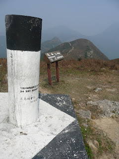
Trigonometrical station and sign on the summit of
459 meter high Keung Shan, Hong Kong's 64th highest hill
Still one peak over from the end point of Stage 5 --
so, yes, still some ways to go to hike's end
To be continued! :)


No comments:
Post a Comment